GWC’s Weather Week That Was – June 8-14, 2025
GWC’s Weather Week That Was – June 8-14, 2025
Location: South Plainfield, NJ
Latitude: 40.58 N
Longitude: 74.42 W
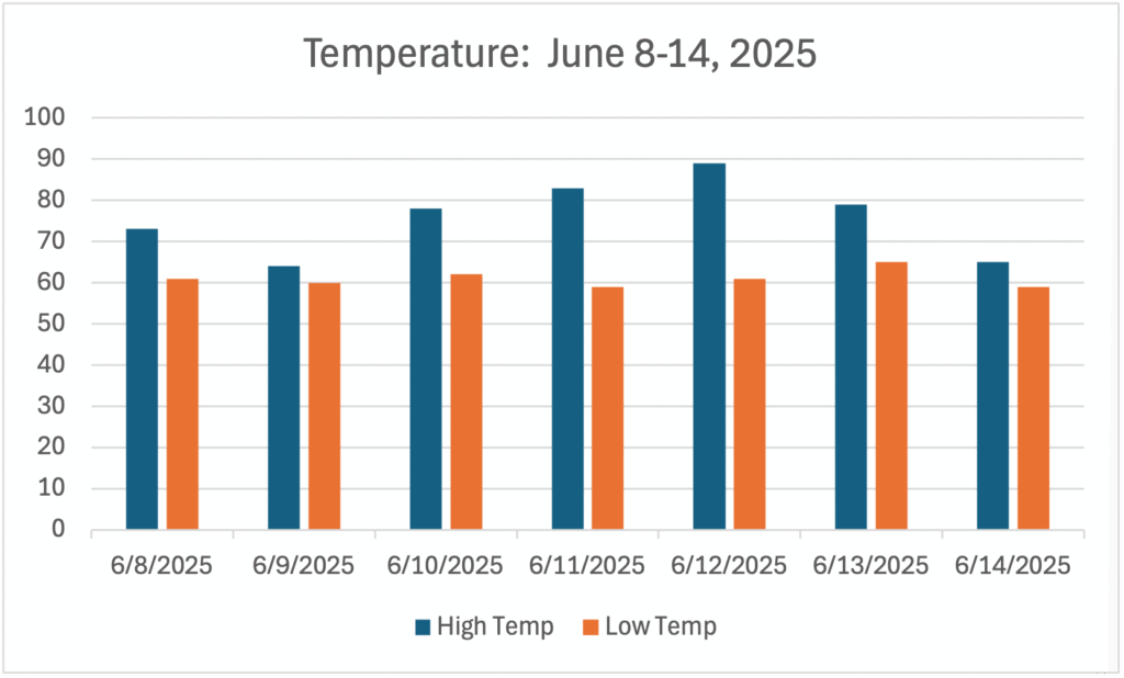
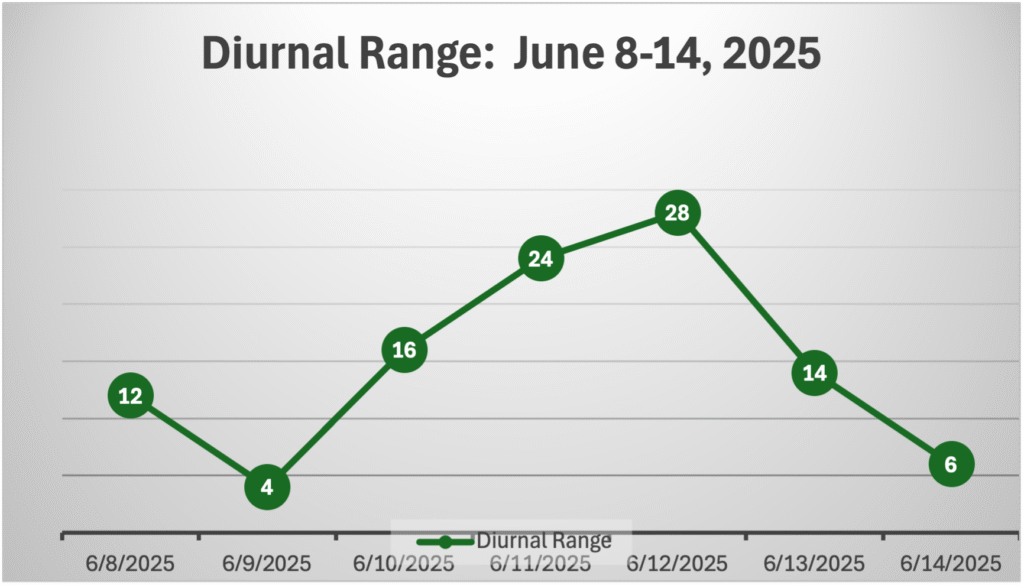
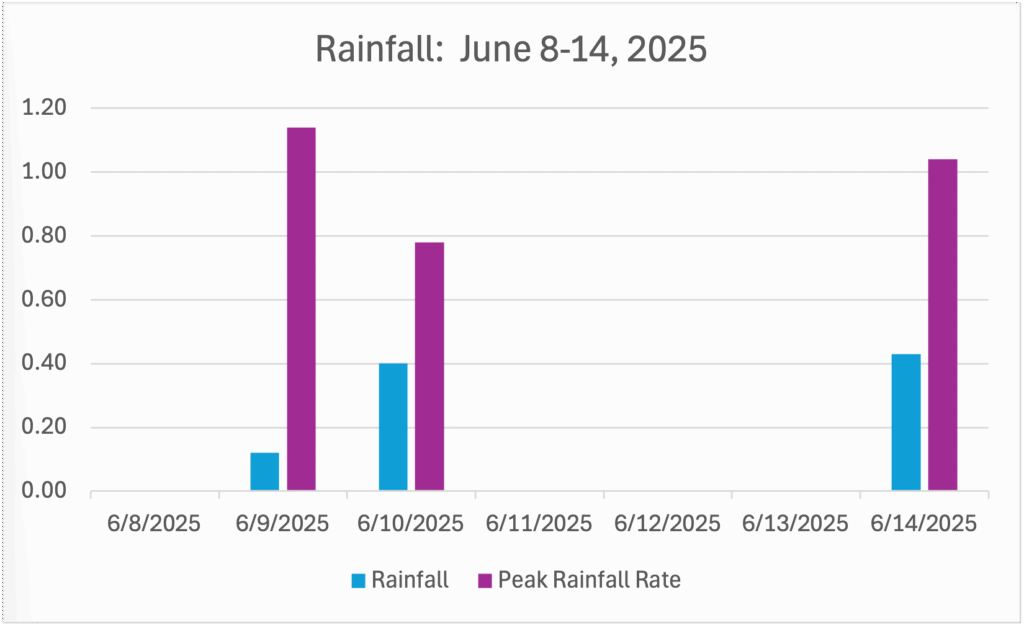
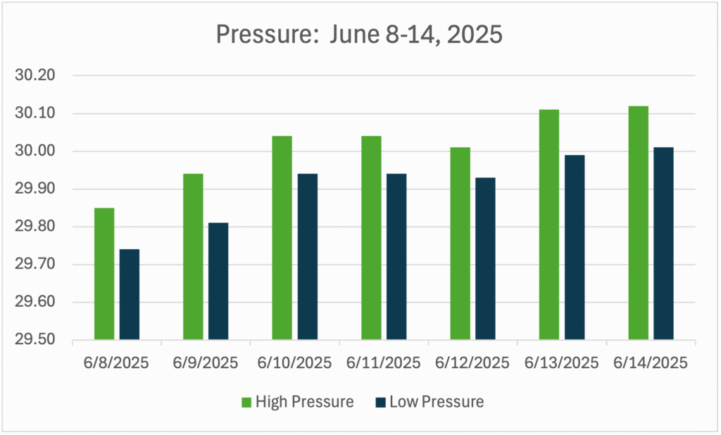
| Date | High Temp | Low Temp | Diurnal Range | Rainfall | Peak Rainfall Rate | High Pressure | Low Pressure | Pressure Change |
| 6/8/2025 | 73 | 61 | 12 | 0.00 | 0.00 | 29.85 | 29.74 | 0.11 |
| 6/9/2025 | 64 | 60 | 4 | 0.12 | 1.14 | 29.89 | 29.81 | 0.13 |
| 6/10/2025 | 78 | 62 | 16 | 0.40 | 0.78 | 30.04 | 29.94 | 0.10 |
| 6/11/2025 | 83 | 59 | 24 | 0.00 | 0.00 | 30.04 | 29.94 | 0.10 |
| 6/12/2025 | 89 | 61 | 28 | 0.00 | 0.00 | 30.01 | 29.93 | 0.08 |
| 6/13/2025 | 79 | 65 | 14 | 0.00 | 0.00 | 30.11 | 29.99 | 0.12 |
| 6/14/2025 | 65 | 59 | 6 | 0.43 | 1.04 | 30.12 | 30.01 | 0.11 |
Temperature for the Week of June 8-14, 2025
- Average High Temperature: 75.9°
- Max Temperature: 89° on June 12th
- Min Temperature: 59° on June 11th
Diurnal Range for the Week of June 8-14, 2025
NOTE: The diurnal range of temperature is the difference between the high temperature and low temperature on a given day.
- Average Diurnal Range of Temperature: 14.9°
- Max Diurnal Range: 28° on June 12th
- Min Diurnal Range: 4° on June 9th
Rainfall for the Week of June 8-14, 2025
- Average Daily Rainfall: 0.14 inches
- Max Rainfall: 0.43 inches on June 7th
- Min Rainfall: 0.00 inches on June 8th, June 11th, June 12th, and June 13th
- Peak Rainfall Rate: 1.14 inches per hour on June 9th.
Pressure for the Week of June 8-14, 2025
- Max Pressure: 30.12 on June 14th
- Min Pressure: 29.74 on June 8th
- Largest Pressure Drop: 0.08 of an inch or 2.7 millibars from 9:00 AM on June 9th to 6:15 PM on June 9th.
- Largest Pressure Rise: 0.23 of an inch or 7.7 millibars from 5:27 PM on June 10th to 8:28 AM on June 11th
Summary
The second week of June 2025 was wetter and cooler than the week before at Greg’s Weather Center in South Plainfield, NJ. There were three days of measurable rainfall that accounted for nearly an inch of rain. There were two days of 80° weather with one of those days falling just short of 90.
There have been 15 days of 80° weather at GWC, but there hasn’t been a 90° day yet. At this point a year ago, there were 20 days with high temperatures of at least 80 degrees and no 90-degree days yet. Rainfall so far this month is running behind the average with only a little over an inch.
The barometer was mostly steady this week with no real significant rises or falls in pressure. There were no big storms or severe weather this past week. There was a larger presence of haze in the skies over GWC this week. Smoke from Canadian wildfires have pushed eastward resulting in the haze.
The increase in smoke and haze coupled with increased heat and humidity produced air quality alerts around the Garden State and the New York City metropolitan area on Wednesday and Thursday. The most uncomfortable day was Thursday with many locations hitting 90° for the first time while dew points climbed into the upper 60s.